Published on September 20 2024 In Scientific news
Tracking the metamorphosis of Arctic landscapes
An article by Valérie Levée, science journalist
In the Arctic, climate change is synonymous with thawing permafrost, a phenomenon that Frédéric Bouchard observes and measures on the ground and from the air.
Just back from Cambridge Bay, Frédéric Bouchard is preparing to leave for Churchill. It's a busy time for field work. But he and his team have chosen to take the train from Winnipeg to Churchill. "With our fast-paced, noisy lifestyle, I'm sensitive to slowness and silence. It's good to sit and wait," says Frédéric Bouchard. Two days on the train gives us time to discuss science, get to know each other better, and watch the scenery pass by. "We go through the prairies, cross the boreal forest and end up in the coastal tundra. For me, it's almost a pilgrimage through landscapes," says the geologist, who is particularly interested in geomorphology, or the formation of landscapes. And if there's one place where landscapes are changing rapidly, it's the Arctic, where the permafrost is thawing. An assistant professor at the Department of Applied Geomatics at the Université de Sherbrooke for the past three years, Frédéric Bouchard's research focuses on identifying signs of permafrost degradation.
A changing landscape
A prominent sign of thawing permafrost is the formation of thermokarst lakes. "When ice-rich soil thaws, the ground sinks. This creates a basin, and when it fills with water, it creates a thermokarst lake," explains Frédéric Bouchard. But there are other signs, such as changes in the hydrology of surface and groundwater, which carry sediments, even mercury and other heavy metals. These sediments can then change the turbidity of a downstream river, and the mercury can enter the food chain. Methane emissions from thawing peat soils are another much-publicized sign of thawing permafrost.
« People imagine that if there's permafrost everywhere, there will necessarily be greenhouse gas emissions everywhere, but that's not the case. When an environment rich in frozen organic matter that has been sequestered for millennia thaws, it provides food for microbes that produce CO2 or methane. But in the case of permafrost in rock or sand, there's no organic matter, so it doesn't produce CO2 or methane," adds Frédéric Bouchard.
At the same time, the Arctic is becoming greener. "Vegetation is flourishing in some places, capturing CO2 through photosynthesis, and carbon is accumulating in the form of peat moss or in woody matter such as roots and branches," he continues. The two phenomena are in opposition, and the outcome is still unknown.
Combining fieldwork and remote sensing
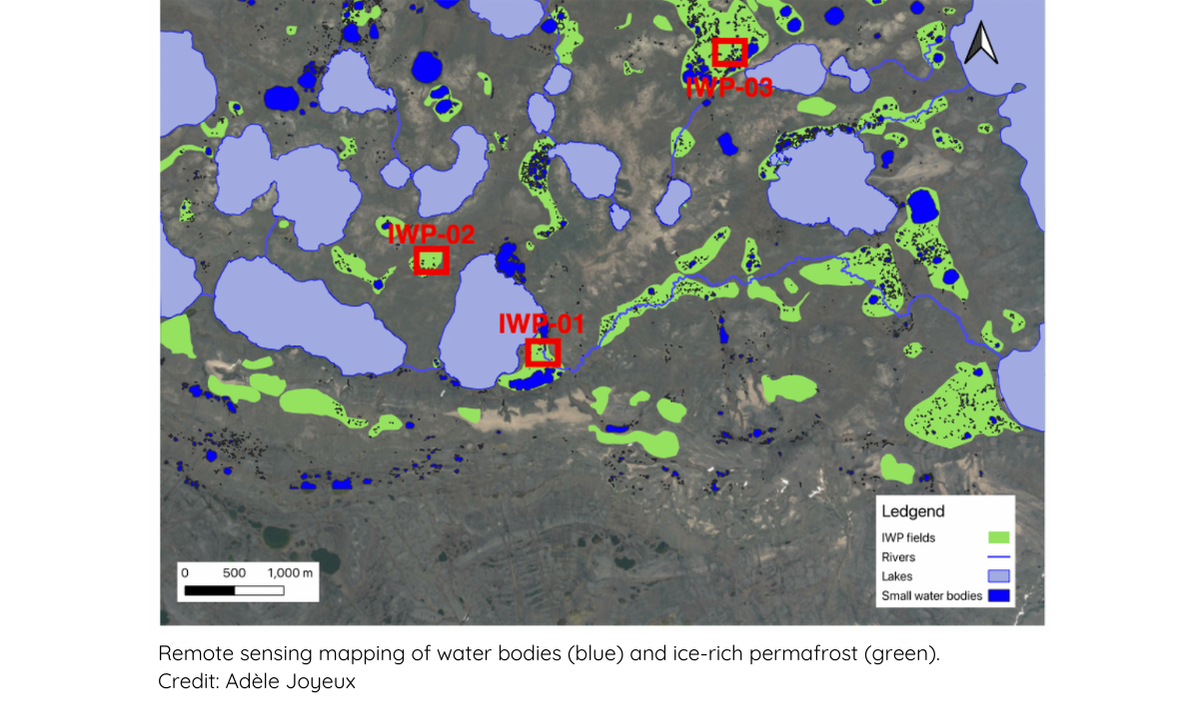
To observe and measure these phenomena, Frédéric Bouchard regularly travels to the Arctic with a multidisciplinary team of geomorphologists, geochemists, microbiologists, and geophysicists. "We go to the same place, find a common vocabulary, and do different studies, but at exactly the same site. At Churchill, microbiologists will collect DNA to do metagenomics and determine bacterial assemblages. We'll also be taking frozen peat cores to do carbon-14 dating at different depths to see if the ecosystem is in carbon source or sink mode," he explains. Earlier, in Cambridge Bay, his team installed sensors along a river at sites likely to receive sediment from thawing permafrost.
Of course, permafrost is not just thawing in Churchill and Cambridge Bay, and it would be impossible to cover the entire Arctic with field studies. To gain a broader understanding of thawing permafrost and its impact on the transformation of Arctic landscapes, we need to use remote sensing and geomatics tools. "In the electromagnetic spectrum, each wavelength has its own relevance," explains Frédéric Bouchard. For example, measurements in the red and near-infrared wavelengths can be used to calculate a vegetation index (NDVI for Normalized Difference Vegetation Index) and assess the vigor of plant cover. Because water absorbs near-infrared light, this wavelength is also used to map lakes. Further down the electromagnetic spectrum, radio waves are sensitive to soil moisture and are used to track freeze-thaw cycles in permafrost. "Depending on the objectives of the project, if we want high resolution over a small area or, conversely, a large area with lower resolution, we use drone images or satellite images," adds Frédéric Bouchard. Remote sensing data validated by field observations can then be used to study larger landscapes.
Living in a changing landscape
The landscape is not just a panorama to be contemplated. It's also an area where communities live and move, and they have a front row seat to the changes. The Inuit of Cambridge Bay used to harpoon Arctic char. Now they say the fish are harder to catch because the water is murkier," says Frédéric Bouchard. We wonder if it's related to the thawing of the permafrost upstream, which is sending more sediment into the rivers. It's a question of basic science, which becomes very concrete downstream when it alters the fish habitat on which populations depend for their traditional way of life.
Aboard the train that will take him to Churchill, he will have a front-row seat to the consequences of a landscape transformed by thawing permafrost. When the track buckles, forcing the train to slow to 20 km/h, he'll have plenty of time to contemplate the scenery.
To learn more
Bouchard, F., Fritz, M., & Sjöberg, Y. (2022). Redrawing permafrost outreach. Nature Reviews Earths & Environment, 3(1)
https://doi.org/10.1038/s43017-021-00255-8
Bouchard, F., Fortier, D., Paquette, M., Boucher, V., Pienitz, R., & Laurion I. (2020). Thermokarst lake inception and development in syngenetic ice-wedge polygon terrain during a cooling climatic trend, Bylot Island (Nunavut), eastern Canadian Arctic. The Cryosphere, 14(8), 2607–2627.
https://doi.org/10.5194/tc-14-2607-2020
Bouchard, F., Laurion, I., & Gandois, L. (2022). Dégel du pergélisol et émissions de gaz à effet de serre dans le Nord: pas si simple. Le Climatoscope 4
Bouchard, F., MacDonald, L. A., Turner, K. W., Thienpont, J. R., Medeiros A. S, Biskaborn, B. K., Korosi, J., Hall R. I., Pienitz, R., & Wolfe, B. B. (2017). Paleolimnology of thermokarst lakes: a window into permafrost landscape evolution. Arctic Science, 3(2), 91-117.
https://doi.org/10.1139/as-2016-0022
Popularised publications
A comic strip created by a group of scientists: Bouchard, F. Fritz, M., Malenfant-Lepage, J., Nieuwendam, A., Paquette, M., Ashley, R., Siewert, M., Sjöberg, Y., Veillette, A., Weege, S., Harbor, J., & Habeck, O. et les artistes: Nääs, H., & Ross, N.
Frozen Ground Cartoons - https://frozengroundcartoon.com
Bouchard, F. (2022). Ici La Terre, Dix aventures scientifiques qui ont changé notre image du monde. Éditions MultiMondes - https://editionsmultimondes.com/livre/ici-la-terre/
_____
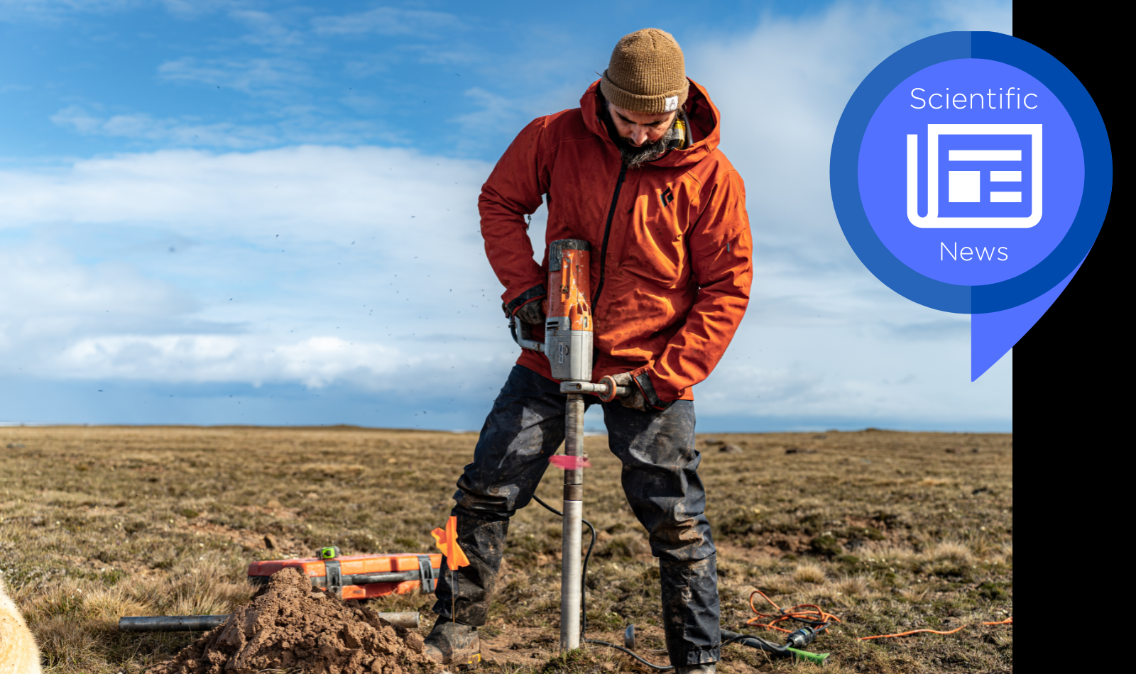
Image in header of article: Frédéric Bouchard taking a permafrost core sample at Ikakultutiak, near Cambridge Bay. Photo by Élise Imbeau
Back to news