Published on May 5 2021 In Scientific news
Manicouagan, yesterday, today and tomorrow
A text by Valérie Levée, science journalist
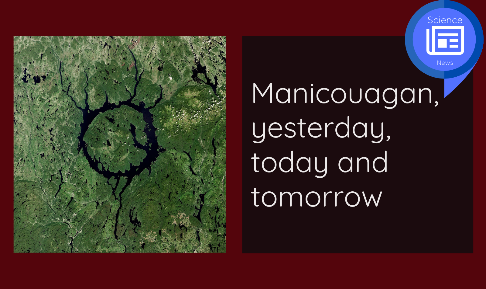
Manicouagan is more than just a hydroelectric dam and its vast reservoir nestled in a meteorite crater. It is also a river, from its mouth to the lake. In fact, it is an entire ancestral territory, the homeland , or Nitassinan, of the Innu community of Pessamit. At the intersection of these perspectives is geography, which is not only physical but also cultural and historical.
C’est avec cette triple approche géographique que le projet de recherche « Dynamique du territoire ancestral innu (Nitassinan) à travers l'étude morpho-sédimentaire et socioculturel du lac-réservoir Manicouagan », entreprend de comprendre les conséquences des installations hydroélectriques sur le paysage et sur la vie des Innus.
It is with this triple geographical approach that the research project " Dynamique du territoire ancestral innu (Nitassinan) à travers l'étude morpho-sédimentaire et socioculturel du lac-réservoir Manicouagan ", tries to understand the consequences of hydroelectric development on the landscape and on the life of the Innu.
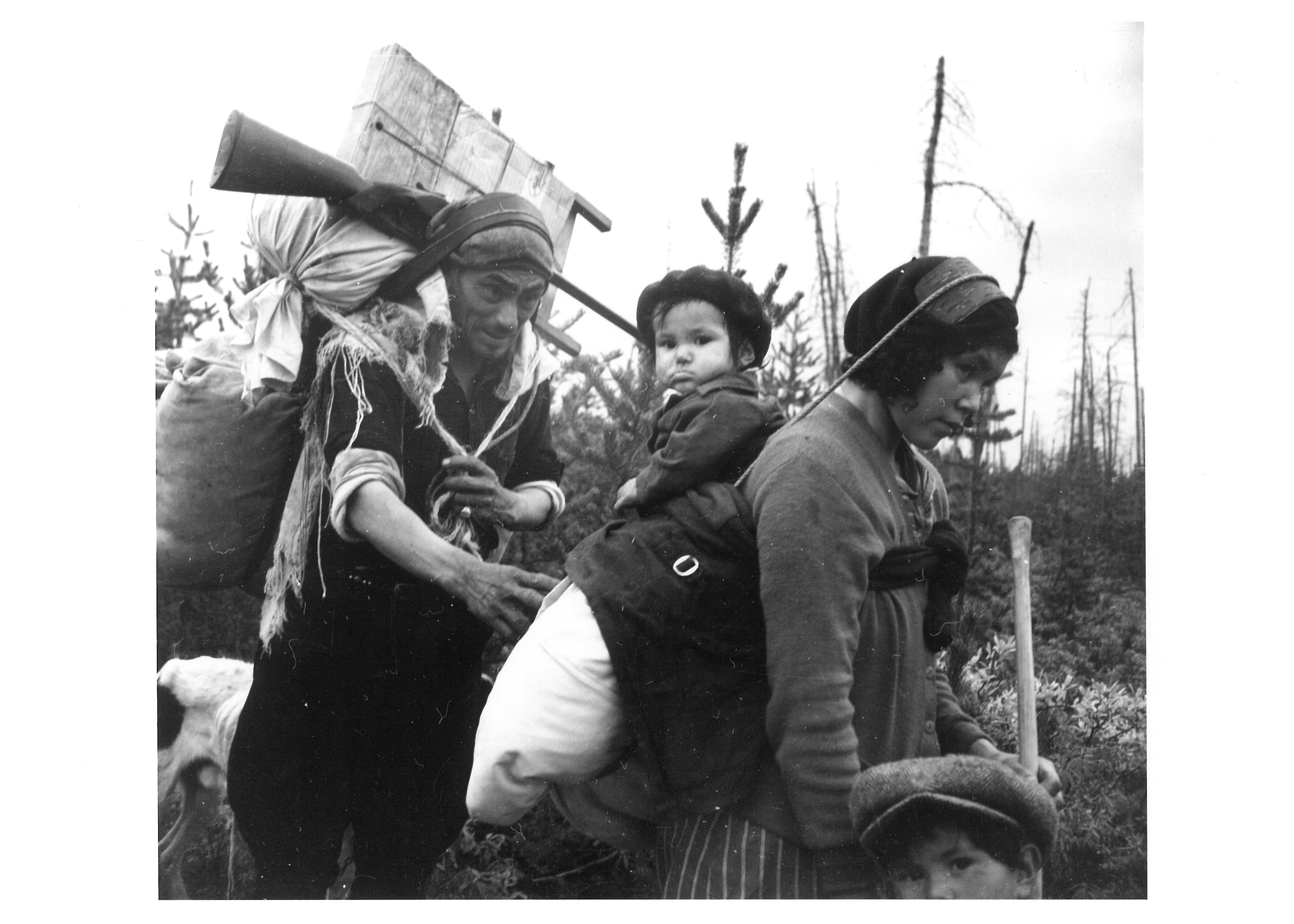
Let's go back to the days before the white man encroached on Nitassinan. "The Innu moved along the rivers, which were like highways to navigate the territory following a seasonal cycle," says Justine Gagnon, assistant professor affiliated with the Canada Research Chair in Indigenous Heritage and Tourism (CIHT).
The Innu way of life alternated between sites on the coast in the summer and, in the winter, camps along the river to track game. The creation of reserves, residential schools, forestry and mining activities gradually restricted the Innu's movements and undermined their occupation of Nitassinan.
"There was already a process of sedentarisation and, like a perfect storm, the dams were added," says Professor Caroline Desbiens, CIHT Chairholder.
The impounding of the Manicouagan reservoir in 1969, followed by flooding of the camp sites near the riverbanks under 130 metres of water, consequently put an end to a certain form of occupation of Nitassinan. But "one should not think that the Innu have completely stopped accessing their territory. The families have gone back to the forest via industrial roads, no longer using canoes but cars," notes Justine Gagnon. A new form of occupation of the territory is possible and the research project, jointly financed by INQ and Sentinel North, aims to promote territorial development through the development of Indigenous heritage and cultural tourism.
Geographers in action
Léo Chassiot is a post-doctoral researcher and the initiator of the project with Patrick Lajeunesse, professor of geomorphology in the Department of Geography at Université Laval. Using underwater LiDAR and acoustic imagery and by examining sediment cores, Léo Chassiot and his team are studying the lake bottom to produce a bathymetric map, revealing the sunken relief and seeing how the territory has been modified by the flooding by comparing it to aerial photos taken before the dam was built.
"When 130 metres of water are added to banks made of unstable deposits, there can be landslides that mark the landscape and are recorded in the sediments. We can see sections of banks that have slipped, river channels that have been flooded," explains Léo Chassiot, "and we can also see the banks of the former lake, so we can picture the territory occupied by families some 60 years ago".
"This is where our approaches meet because in cultural and historical geography, we also discuss aerial images with Innu who knew the rivers before the dam to reactivate their memory and find out how their families occupied certain parts of the river," explains Justine Gagnon. There is a rich heritage to be documented, as much on the physical level of the Manicouagan River watershed and its aquatic environments as on the historical and cultural level. "The Lake Manicouagan and Monts Groulx region is relatively unique and understudied," says Léo Chassiot. This explains why UNESCO designated the region the Manicouagan-Uapishka Biosphere Reserve (RMBMU).
Towards a contemporary occupation of Nitassinan
This natural and cultural heritage must become the pillar of cultural tourism and a reappropriation of the territory by the Innu. This is the objective of both the research project and Uapishka Station, which was established on the eastern shore of the Manicouagan reservoir and co-founded by the Innu Council of Pessamit and the RMBMU. Uapishka Station is therefore a natural partner in the project and it is expected that Innu will participate in the field work. "The research process is also a means of transmission of this heritage by the members of the community who are also partners in the project," says Caroline Desbiens. Subsequently, the research results will allow Uapishka Station to develop Innu cultural content to enrich its tourism initiative, which is still focused on adventure tourism. "We hope that the development of knowledge about heritage sites will help to revitalize these sites," Caroline Desbiens continues. On the other hand, "going back to the territory is not just about getting in a canoe and going up the river like the ancestors did. There are many ways to connect with the territory." Moreover, "the Innu of Pessamit have an agreement with the Ministry of Natural Resources to monitor snowmobile activities in the Groulx Mountains during the wintertime. Territorial agents from Pessamit are mobilized over the entire Nitassinan territory," adds Léo Chassiot. "Today, being a land guardian is a contemporary manifestation of being Indigenous," says Caroline Desbiens. And the research project, in conjunction with Uapishka Station, could lead to other forms of occupation and management of Nitassinan.
Affiliations

1. Caroline Desbiens, Professor, Département de géographie, Université Laval
- Holder of Canada Research Chair in Indigenous Heritage and Tourism (CIHT)
- Affiliate researcher of Institut nordique du Québec
- Associate researcher of CIÉRA
- Member of DIALOG network
2. Justine Gagnon, Professor, Département de géographie, Université Laval
- Affiliate researcher of Institut nordique du Québec
- Associate researcher of CIÉRA
- Member of DIALOG network
3. Léo Chassiot, chercheur post-doctoral au Département de géographie de l’Université Laval
- Sentinel North Postdoctoral Fellowship
Partners
References
Gagnon, J., 2018. Seeing the unseen: an Indigenous heritage’s mapping project. Proc. Int. Cartogr. Assoc. 1, 1–7. https://doi.org/10.5194/ica-proc-1-42-2018
Gagnon, J. , 2019 Nitshissituten : mémoire et continuité culturelle des Pessamiulnuat en territoires inondés. https://corpus.ulaval.ca/jspui/handle/20.500.11794/34006
Gagnon, J., Desbiens, C., 2018. Mapping memories in a flooded landscape: A place reenactment project in Pessamit (Quebec). Emotion, Space and Society, 27, 39-51.
L’Heureux Houde, F.-X., 2017. Géomorphologie d’un lac de cratère d’impact météoritique profond ennoyé par un barrage hydroélectrique : le cas du lac Manicouagan, Est du Québec. Master’s thesis, Université Laval, 78 pp.
 Science News
Spotlight on Northern Research | An initiative of Institut nordique du Québec
To celebrate Quebec's excellence in northern research and to highlight the various challenges and issues related to these territories, Institut nordique du Québec offers you a series of articles dedicated to the research conducted in its community.
Over the months, you will discover a multidisciplinary research community whose strength lies in the complementary expertise of its members. You will meet individuals who share a strong attachment to the North and who are dedicated to producing, in collaboration with the inhabitants of the region, the knowledge necessary for its sustainable and harmonious development.
You are invited to relay this and subsequent articles to your network, thus enabling the greatest number of people to discover the different facets of northern research and the many faces that animate it. Together for the North
Back to news